With the capitulation of France in June 1940, a territorial and administrative separation was set into motion and this proved to be a fundamental change in the geography of the war in the country. France was divided into two zones under the armistice agreement with the Nazi Germany. The northern sector including Paris, major ports and manufacturing hubs was directly occupied by the German military. In the meantime the southern zone was formally independent, and governed at Vichy by the government of Marshal Philippe Petain. This southern half was termed the Free Zone, but was actually highly constrained by the armistice and German control.
Practically, the Occupied Zone was of strategic value to the Germans, such as access to Atlantic ports, transportation infrastructure and industrial production. The southern zone operated with semi-independence and enforced its own policy on domestic issues and released German interests and demands politically and economically. What it produced was a two-geography system which defined domestic policy as well as the foreign policy of France.
Political and military implications of the territorial split
The Franco-German armistice cut down France military power considerably. The Vichy regime only had a small army whose only role was to keep internal order and defend the colony. Large military installations in the north were annihilated or incorporated into the German forces, with the naval forces mostly remaining in ports in the south, including Toulon. The situation worsened in July 1940, when the British Royal Navy made a surprise attack on Mers-el-Kebir to ensure ships did not fall under the control of the Axis, killing more than one thousand French sailors.
German and Italian expansion in the south
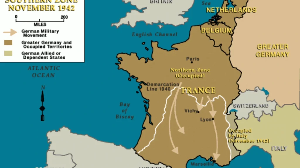
In November 1942 after the Allied invasion of French North Africa (Operation Torch) the precarious balance of the two-zone structure was destroyed. As a retaliatory measure, German and Italian troops initiated Operation Anton whereby the entire southern zone was occupied. The move terminated any pretence of independence on the part of the Vichy regime and exposed all of France to the power of the Axis until the process of liberation commenced in 1944.
The socio-economic divide and governance challenges
The economically important center of France was occupied by the Germans, and such cities as Lille and industrial centers along the Rhine and Seine were there. German troops diverted much of this ability to the Axis war machine, reusing factories and infrastructure. The people were subjected to forced labor drafts through the Service du Travail Obligatoire and all dissenting efforts were harshly suppressed through counter measures.
Agricultural economy and rural life in the south
The southern region was more agrarian and less industrialized which manifested a different reality in economic terms. The city authorities of Vichy prioritized conventional rural beliefs and self-sufficiency, yet there were food shortages, rations and economic stagnation. The corporatist economic model of the government tried to nationalize sectors under state control but failed to deal with the overall disruption of the war.
The comparison between northern industrialized occupation and South stagnation under controlled conditions enhanced differences in the regions and contributed to the complexity of logistics in war-time governance.
Strategic significance of geography in warfare
French geography played a very crucial role in both Axis and Allied strategies. The possession of northern ports by Germans gave direct access to the English channel and the Atlantic Ocean, which were critical in the operations of the U-boats and in the counteracting of Allied naval traffic. Highways and railways between the Paris-Bordeaux and the Mediterranean coast became important channels of movement of troops and transfer of resources.
Scuttling of the fleet at Toulon
Among the most historical events related to the geography of Vichy took place in November 1942, soon after the events of Operation Anton. The naval officers of the French fleet at Vichy carried out a planned scuttling of more than 70 vessels, as German troops approached Toulon to capture the French fleet. This was a rebellion, even though the regime assumed a collaborative stance, which deprived the Axis of a potent naval resource and is still a unique instance of opposition among the ranks at Vichy.
Resistance geography and clandestine networks
The rugged topography of the southern zone and closeness to Spain and Switzerland made it a perfect place to hide anti-persecution activists and oppressed people. The networks such as the Maquis would span the regions of Massif central, the Alps, and the Pyrenees. This absence of a direct German military presence prior to 1942 allowed resistance movements to organize training camps, print underground newspapers and liaise with Allied intelligence.
Northern repression and underground action
The Occupied Zone, on the contrary, was characterized by more violent suppression, especially after 1941 when the rebels became more active. Raids, mass arrests and deportation were carried out by German forces and the Gestapo, which was often helped by Vichy police. In spite of the threats, sabotage operations were pursued by resistance groups and helped them communicate with the Free French forces in London.
Diplomatic and symbolic dimensions of the geographic divide
At first, the Vichy government was an acknowledged legal authority in France that was recognized by several neutral countries, as well as the United States. But the world began to change as the regime continued to enhance its cooperation with Germany and its anti-Semitic policies. By 1942, following the complete occupation of the south, diplomatic recognition was lost at a very fast pace. The Free French movement led by Charles de Gaulle found support around the world, particularly in the Allied countries and started to consolidate their control over overseas colonies.
Moral symbolism and national legitimacy
The separation of occupied and of free zones reflected more fundamental divisions within French society. Vichy leaders described their government as the guardian of national custom and moral order, in stark contrast to the apparent anarchy of the Third Republic. Their alliance with Germany, however, discredited this story particularly at the time when resistance fighters became more visible. By 1944, the north-south divide was not only geographical, but also representative of the overall conflict between authoritarianism and republicanism.
Post-liberation consequences of territorial division
After the landings on the D-Day and the liberation of France in 1944, the territorial divide was wiped out, although its heritage was not forgotten. The reconstructing process frequently gave moral authority to those regions that had been more engaged in resistance activities especially in the south. On the contrary, the regions where collaboration was more common were subjected to the social investigation, trials, and purges.
Memory and historical debate
The Vichy period is a subject of debate in France. The territorial division turns out to be the center of attention when it comes to complicity, resistance, and national identity. In the education, political and cultural spheres, the northsouth divide would continue to be used as a benchmark in studying how geography contributed to not only the occupation experience but also the reconciliation and culpability that followed the war.
The examples of the north and south divide in Vichy France would be the best illustration of the way in which geography can order political power, warfare, and social experience in a moment of crisis nationwide. The physical landscape of France was bound up with its fate in the war, between the administrative limits and the strongholds of the resistance. This spatial division cut deep into historical memory as the country moved through occupation, collaboration and liberation, providing a lasting understanding of the geopolitical aspects of war.